![]()
Mt. Halla ('san' is the Korean word for mountain) lies at the heart of
Cheju-do - visible from almost any point on the island. Numerous trails
of varying length and difficulty crisscross the park - all making for
a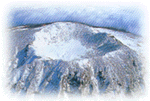 great view on a clear day. The shortest hike to the nearly 2000 meter
summit takes a little over five hours roundtrip while some of the longer
hikes can double that. Camp sites are available as are huts for those
without tents. Photo opportunities from the top can be spectacular -
rolling hills, orchards of oranges, green farmland, the distant ocean
- don't forget your camera!
great view on a clear day. The shortest hike to the nearly 2000 meter
summit takes a little over five hours roundtrip while some of the longer
hikes can double that. Camp sites are available as are huts for those
without tents. Photo opportunities from the top can be spectacular -
rolling hills, orchards of oranges, green farmland, the distant ocean
- don't forget your camera!
 Hours
Hours
- It's a mountain - go when you want. That said it's best to go early in the morning when the sky is usually clear. By most afternoons cloud cover has descended over the top of the mountain and reduced visibility substantially. You also need to keep an eye on the weather, something the park rangers will also do of course but be prepared. It can be a lot colder near the top than down below - you don't want to get caught in the cold and rain (or snow) at the top without having proper clothing.
- It's a mountain - go when you want. That said it's best to go early in the morning when the sky is usually clear. By most afternoons cloud cover has descended over the top of the mountain and reduced visibility substantially. You also need to keep an eye on the weather, something the park rangers will also do of course but be prepared. It can be a lot colder near the top than down below - you don't want to get caught in the cold and rain (or snow) at the top without having proper clothing.
-
Transportation
Bus: any bus moving along the Cross-Island Highway (highway 1 or 2) will take you past at least one of the park or trail entrances. Just let the driver know which one you're headed for - check a map ahead of time.- Car: get one of the maps available at the airport, tourist office, car rental agencies, etc. and decided where you'd like to go. Getting around is generally quite easy (July and August can be a bit tougher) on either highway 1 or 2.